The Wonderland Trail - Mt. Rainier National Park
Mount Rainier National Park's Wonderland Trail circumnavigates Mt Rainier over the course of 93 miles. The trail is a classic loop that is high up on the list of desired routes for backpacker around the US. While it is generally backpacked in 7-10 days, I took on the challenge of finishing it in 3.
 |
Trip Logistics
The Wonderland Trail is a very popular backpacking loop which makes permits difficult to obtain. When doing it only 3 days though, the ability to get permits becomes a bit easier as there is only a need to obtain 2 campsites. I missed the lottery period to get permits but once the general reservations opened, I was able to have a couple of options for itineraries. Ultimately I settled on completing the route counter-clockwise, the abnormal direction, in mid September. This would give me a bit more time to train in the summer. I would start at Narada Falls Trailhead and hike to Sunset Walk In Campground (30 miles, 8k ft of gain). From there I would take the Spray Park Variation of the trail to South Mowich River Campground (25 miles, 6k ft of gain). The final day I would hike back to car at Narada Falls (32 miles, 10k ft of gain).
For gear I needed to keep it very light which required some gear upgrades. My backpack was a 28L fastpacking oriented pack. My sleep system consisted of a quilt, a single person tent, and a fancy new lightweight Thermarest sleeping pad. On trail I only carried a single liter of water with the ability to expand to another liter if necessary. My layers were light with a light rain jacket, puffy, light fleece, long underwear, and a single extra pair of socks. I carried 3 days worth of food and a stove.
93 miles
Trip Report
The Lead Up
My initial goal to finish the Wonderland Trail was to try and fastpack it. This meant running as much of the trail as I could with as small and light of a pack as I could get away with. To accomplish this I began training in early spring. Sadly training was not meant to be as I "ran" into a string of calf and foot tendon issues. This resulted in a few weeks of good training, some time off, then ramping back up. So after my final injury stint a month and a half out, it was settled. I would be completing long days of walking instead of running.
I drove out of Seattle on a Wednesday afternoon headed for the White River Wilderness Information Center and Ohanapecosh Campground. I picked up my permit, and then headed over to the campground where I scored a first come first serve campground. The rest of the day was spent walking around, taking in the quiet, and reading. A nice, calm, and relaxed evening leading into a long few days.
Day 1
I woke up at 3am at Ohanapecosh Campground still fairly tired. Falling asleep at 8pm is very difficult when you are accustomed to sleeping a few hours later. By 3:30 am I was driving through the empty meandering park roadways. It was foggy and wet, probably the foggiest I had every driven in. As I drove through the park I thought "Wow, I cannot see anything. What if there is another car or something around the bend?" The road wound up the canyon with the occasional blind turn. Thankfully nothing was hit except the persistent light sprinkle of raindrops.
By 4am I was at Narada Falls Trailhead. The parking lot was pitch black and empty. I quickly got my gear together and set off, no way was I hanging around that lot in the dark. My turnoff onto the Wonderland Trail arrived within minutes. I turned left, beginning my 93 mile counterclockwise jaunt around the mountain.
 |
| Headed left! |
I quickly shed my fleece and rain jacket. The temperature was only mid 50s and I would be in tree cover for the next 10 or so miles. After a small climb I began my descent into Stevens Canyon. The terrain around me was pitch black, just my headlamp illuminating the small bit of trail in front of me. No moon was out to assist me and the sun would not rise for another 2.5 hours.
The rain began to pick up, warranting the putting on of my rain jacket. It and the canopy kept me fairly dry for a while. Eventually the trail intersected the windy road that I had driven up on. The road, with nothing above it, highlighted how much the trees were doing to protect me. I scurried across the road and began to head down the trail. Quickly I was met with a warning, the trail is washed out ahead.
This presented me with two options. Follow the trail down and do an off trail re-route or walk the road. The re-route introduced a fair amount of uncertainty. Who knew how far down the trail it was, would I be able to navigate it in the dark, would the river I had to descend to be overflowing? Alternatively the foggy road was sketchy. The right side was a cliff edge with a wall but no shoulder. The left side was a vertical rock face, no doubt blasted out at some point with explosives. There occasionally was a wider shoulder but it always had a bit of dislodged rock from snow, wind, or you know... rain. I could also hitchhike, but that was certainly a no go. While I am not prime kidnapping material, there is still a possibility it could happen.
So the road walk was my choice. The dark windy cliff road that I previously was concerned I myself would hit someone on. I was drenched immediately, my light rain jacket not standing up to the consistent rain. I meandered side to side, trying to use as much road shoulder as I could. A few cars passed, thankfully I could see and hear them from afar.
Eventually the sun began to rise. I'm able to turn my headlamp off and see further in the fog. After a few miles I reached Box Canyon where I would re-connect to the trail. I sat at an interpretive sign with an awning for a bit, snacking and trying hopelessly to dry my rain jacket. I quickly gave up and continued on my way, only to walk through an ankle deep puddle which thoroughly soaked my feet.


I eventually began to descend towards Indian Bar Camp. As I began heading down, the fog began to clear. The alpine meadows, waterfalls, and rock fields were revelaed in their full form. Once there I began to ascend towards Panhandle Gap. The fog rolled in and out with me getting the occasional view. Eventually I reached the gap where I was rewarded with my first bigger look of Mt. Rainier. I could not see the summit but I could see snow!

 |
| Heading towards Panhandle Gap |
I began my descent towards Summerland and White River. The down was endless, but I eventually reached the White River Campground. At this point the difficulty in the day began. I was making very good time but not feeling great. My feet had never really dried out resulting in the beginning of blisters. My legs were starting to feel very stiff and worst of all my burrito for dinner had begun to burst in my pack. There was some contemplation of getting my partner to give me a ride home or even trying to hitch back to my car. But I worked through baby steps to get back into it. I had literally 3 hours to finish the final 3 miles to my campground, there was time to dry and tape my feet, and the burrito could certainly be eaten with a spoon.
 |
| A look down towards Summerland |
 |
| First peek of Mt. Rainier's summit |
Eventually I continued on with my day. I took on the final 2000 foot climb to Sunrise. I walked slow enough that a few backpackers looked visually confused on what was going on with my pace. At Sunrise I setup camp, crawled into my tent, and went to sleep.
 |
| A view from near Sunrise |
This day started slowly at 6:30 am. I wandered out of camp to see Mt. Rainier basking in the beautiful sunrise glow. Once back at camp I tear down, eat breakfast, and get going. I am on trail and walking by 8:30 am.
My goal for the day was to take it slow and enjoy the experience. The day only had 25 miles and 6k feet of elevation gain on the docket. Plus it was sunny out! This meant I was going to take my time, soak it all in, and try and rest myself for my biggest day which would be the next.
The first few miles were fairly calm. A bit of up, a bit of down, and a bit of flat. The sun was out so I got some nice views of the top of Rainier. Eventually the trail starts to head downwards toward the west fork of the White River. I enjoyed some nice views of the Winthrop Glacier and hear the occasional crashing down of rocks.
 |
| Heading out of Sunrise Camp |
 |
| It was sunny! |
 |
| A cute footbridge |
 |
| First full on view of Mt. Rainier |
After a bit of descent I cross the White River and began heading up towards Mystic Lake. It was a bit of a slog but I made good progress. I reached Mystic Camp around noon and am met a couple of trail runners. We had a quick exchange where they mention a group at Mystic Camp was having medical issues and are looking for a ranger. I hike over and meet with the folks having the issue. After a long conversations we determine that while they are both currently stable, it is unlikely they would be able to get out of the wilderness under their own power. The Mystic Lake Patrol cabin was empty so for the first time I pressed the SOS button on my satellite messenger.
Over the next couple hours I slowly communicate with the NPS dispatch via my satellite messenger. They dispatch a backcountry ranger who is hiking in and potentially a helicopter as well which is already was working in the area. While waiting for communication i sit at Mystic Lake due to the better reception for my messenger. Around 4pm in between messages I hear a faint whir, which gets louder, and soon there is a helicopter hovering over the lake moving in for a landing.
After the dust settled I met the two rangers (WEMTs, paramedics?) who would be handling the situation. We conducted the patient hand off on the way down to camp. One of the NPS rangers guessed I had my WFR and gave me a compliment which was extraordinarily validating especially since I took the course almost 3 years ago. The rangers quickly decide that extraction is the appropriate course of action, especially as the fog begins to roll in this evening. We pack up camp and move everything to the helicopter. Once the helicopter is packed up I say my thank yous and departed on my journey to South Mowich River Campground. At this point there was still 15 miles on the docket and it was 5pm, I would be in for some night hiking.
Eventually as I descend towards the Carbon River, I run into the wilderness ranger who was tasked with responding on foot. Turns out the helicopter was not able to take off and the group would be spending the night anyway. She still needed to head up to Mystic Lake as the helicopter team did not have the key to the patrol cabin there. We have a nice conversation and both continued onward towards our destinations.
Eventually I reached Spray Park Trail, the big climb of the day. The fog had completely rolled in at this point and it was beginning to get dark. I climbed and climbed and climbed, eventually passing the Cataract Valley Campground. Once there, the headlamp went on and the night hiking began. Soon after reaching that campground, the rain began well. Thankfully it was just a gentle sprinkle but just enough for a rain jacket to be worth it. Eventually I reach my high point for the day and begin the descent. I could see that the fog had burned off and the silhouette of the ridges around me in the dark.
 |
| First suspension bridge for the trip! |
The descent to my campground was much longer than I had expected. Lots of switchbacks and a fair amount of wet. At some point I saw a bear's eyes reflecting the light of my headlamp. We both stood and stared at each other for 30 seconds, the bear occasionally shifting to hide itself more behind the tree it was at. I eventually decided to go my separate way, dropping down the downhill side of the trail and heading to the trail below rather than walking within 20 feet of the bear. It was super slick and I almost wiped out quite a few times.
At 10:45 pm I finally had reached my campground. I pitched my tent while heating up my meal. By 11:30pm I was in bed and trying to go to sleep, my biggest day yet coming up.
Day 3
I woke up at around 5:30 am so I could be ready to go once the sun came up. The ultimate goal for the day was to not finish in the dark. With ~33 miles and 10k feet of elevation gain I certainly would be cutting it close. This also was finally the morning I got to hike in dry socks, I had saved them up for this final day. By 7am I had left the campground and started my first climb of the day. Sadly it quickly began to sprinkle and within an hour my dry socks became wet socks.

The views of the day were amazing. I went into the western section of Mt. Rainier not expecting anything out of the terrain but it was absolutely gorgeous. The rock wall gained elevation dramatically, the glacier runoff created beautiful valleys, and the fog weaved in and out of the landscapes creating beautiful views.


 |
| The second and final suspension bridge of the trip |
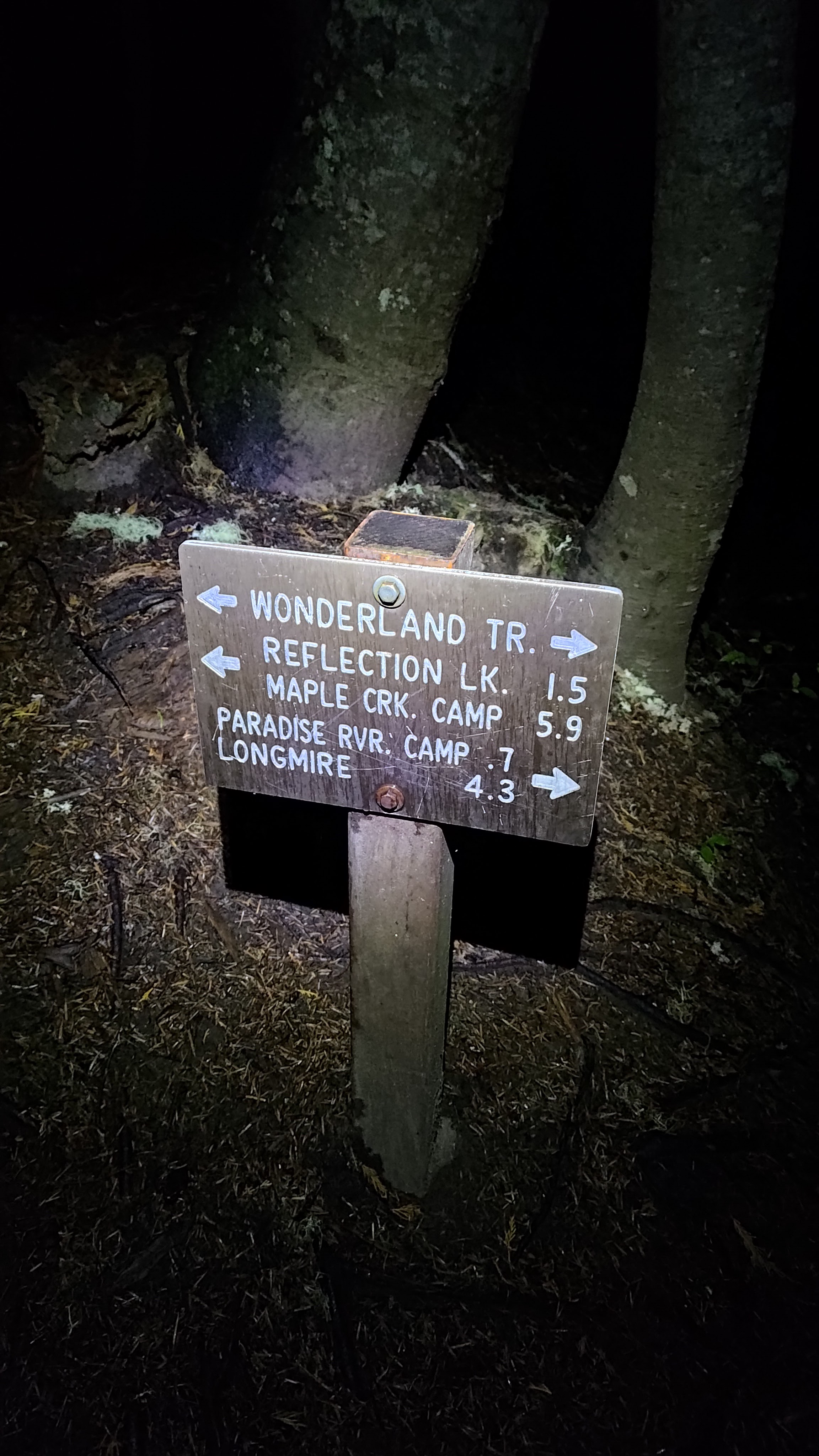
Through the day I got to cross a few rivers, walk over a large suspensions bridge, and watch some large marmots peeking out of their holes. I passed some old rocky dams and a pretty patrol cabin. Eventually I made it to Longmire, the signal that I was almost home. From there the sun began to set and I set off for my final 4 miles up. The rain began right as the sun went down and I finished my final ascent to Narada Falls in the dark. The trail was fairly uninteresting at this point which turned this into a slog. Once I hit the turn off to Narada Falls Trailhead junction I knew I was done. I tackled the final quarter mile and made it to my car. The rain was coming down fairly consistently at this point so I quickly packed up the car and got on my way back to Seattle.
 |
| I was so happy to see this sign I even took a picture with it. |
Overall the Wonderland Trail was an amazing experience. The trail was beautiful and I got to experience a fair amount of the views it was known for. It certainly was physically difficult and the medical emergency added additional mental burden to that. Would 100% do it again, just maybe in 5-10 days instead.
Happy hiking!
-m


Comments
Post a Comment