I continue to have a weird obsession with Cone Peak in Los Padres National Forest. As the second highest peak in the Santa Lucia Range, Cone Peak has long sweeping coastal views and a fair amount of prominence making it an appealing destination. Its inconvenient and bushy approach also adds allure to the average masochist, both having the benefit of reducing the number of folks on trail. So naturally 2024 needed to be started with a long long walk through the woods.
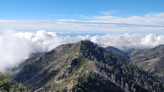 |
Looking down from Cone Peak
|
Trip Logistics
This is a long day hike. We started at dawn and finished right as the sun went down for a car to car total of 9.5 hours. As for directions, the hike itself has few intersections so not a lot of places to get turned around. The trail is easy to follow except for about a 1 mile section where the trail disappears and some bushwhacking is required. Thankfully the trail moves up a drainage which has pink marking ribbons every 50 meters or so. We never needed to break out the GPS but having a topo map and an understanding of where you are headed will be helpful.
The trails in Ventana Wilderness tend to be varying levels of overgrown. On Vicente Flat Trail we had to push through bush and downed trees. The edges of the trail occasionally were littered with poison oak and there is definitely an abundance of ticks. Pants and longs sleeves are definitely recommended.
Trip Statistics
22 miles
6,000ft of elevation gain
Map
Trip Report
I came back to visit the Bay Area for the holidays with determination to do something around the Cone Peak. My mind had settled on backpacking, but as the weather forecast started to settle the motivation dropped off. It would definitely be cold, and likely wet. So after arriving in San Luis Obispo my partner in crime, Sam, and I decided suffering through backpacking Cone Peak would not be fun. Therefore the only logical solution was to do it in a day. Thankfully we would be dodging the rain as that was forecasted to roll in at night.
So on the 2nd of January we woke up at an ungodly hour to embark on a 1.5 hour drive to the trailhead. On the way we stopped at a Safeway to fill up on food. To our disappointment, we arrived early enough that the bagels were still from the previous day. Despite this huge set back, we purchased our old bagels and continued on to the trail head. As we wove up Highway 1, the sun slowly rose behind us, projecting a warm orange glow across the sky.
 |
The view north on Highway 1
|
By the time we got to the trailhead, the sun had fully risen.We parked next to one other car at Kirk Creek Campground and were on trail and moving by 7:45 am.
 |
Looking north over Kirk Creek Campground
|
We quickly got into a fairly nice rhythm. Our goal was to avoid getting stuck in the dark and in the rain on the way down. Sam knew that there were some very precarious sections of the trail near the start so the goal was to avoid any chances of falling into them later in the day.
 |
Looking north as we head upwards.
|
 |
A view of a strange patch of coastal redwoods.
|
We continued up and up, moving in and out as the trail contoured around the shape of the mountain. The grade was gradual, occasionally crossing dry creek beds that surely were flowing earlier in the week when it was raining. Eventually we began to exchange the lower coastal foliage for tall bushes and trees. This was also met with a flat bit and the beginning of the downhill to Vicente Flat Campground.
 |
Our first view of Cone Peak
|
As we entered the trees and tall bushes we were quickly met with the standard Los Padres/Ventana Wilderness experience, downed brush. Over the course of our decent it actually was not too bad, a dozen or so sets of trees fallen over the trail, some encroaching brush. We did have to crouch all the way down to power through them though but we stayed off our hands and knees for the day which was a win.
After we charged through the second set of downed trees, a tick was found. This was something I had completely forgotten about and proceeded to strike fear and paranoia into me for the rest of the hike. We immediately commenced our first of many tick checks, thankfully only needing to brush off a single one.
 |
Being swallowed by a tree
|
Eventually we finished our descent in Vicente Flat Campground. This is by far is the ugliest backpacking campground I have ever seen. The beautiful creek running through, the redwoods towering above, and lush shrubbery just make for a horrible place to camp. I would never recommend anyone camping here, it is just so horrible, the antithesis of what anyone wants out of a backpacking site. Please tell your friends how horrible it is and that they should never show up there. Please.
We used the campground as a nice opportunity for a break. We tick checked, ate snacks, and stood in a very large tree. At this point it was 9:45, ahead of schedule.
 |
Entering Vicente Flat Campground. See how disgusting it is.
|
 |
Big tree contrasted with slightly below average sized human
|
After snacking more hiking commenced. We crossed the creek and started to head right, passing a couple of clearly marked signs re-assuring the proper direction to follow. As the trail ascended it slowly became less and less clear. Eventually we were just moving up the gully, following the occasional pink marking ribbon. The trail alternated between the left and right side of the creek. There was the occasional tricky obstacle to bushwhack or jump over but nothing too bad.
 |
The general construction of the gully. Follow the path of least resistance.
|
 |
Occasionally we had to get creative.
|
 |
No butt sliding or hands and knee crawling required
|
Eventually the trail exited the gully, veering up the southern side of the creek. The trail became very obvious but definitely quite thin. The area had definitely burned semi recently, likely the Dolan Fire in 2020. Much of the brush was growing back aggressively over the trail. We continued through, pushing through the occasional downed tree or enthusiastic bush that decided the trail would be its new home. As we ascended the views began to grow and the canyon below got smaller and smaller.
 |
Hurdles after hurdles after hurdles
|
 |
Cone Peak is getting closer
|
 |
Redwoods working extra hard to survive post fire
|
Eventually we were dumped onto Cone Peak Road, a fire road we would continue on for a bit. People used to be able to drive up it but it definitely did not look very well traveled. After a nice little break we continued on. The farther along the road we got though, the clear views began to be exchanged with clouds aggressively rolling in.
 |
Looking East, deeper inland
|
 |
Clouds beginning to roll in aggressively
|
After a mile or two on the fire road we exited on the left, taking the obvious sign marked single track that would eventually lead us to the summit. The trail was quite thin with tons of brush encroaching the path. For the next half or so mile our bodies were in constant contact with the brush.
 |
Can you spot the trail?
|
 |
The clouds continuing to roll in.
|
As we headed up, the clouds to the west began to get closer and closer to us. More paranoia kicked in. Would we get to the summit only for it to be covered in a thick layer of fog. Imagine going through all of this to see nothing, a far too common experience. This meant our hike turned into a fast hike and to a bit of a jog. So for about a mile and a half to the summit we were pretty much booking it in hopes of securing a good view. We had gone through too many bushes to not be rewarded with a good view.
 |
Looking back on our final turn towards the summit.
|
 |
A look out onto the clouds approaching us.
|
Eventually we made it and beat the clouds! The reality was the clouds were never going to fully encompass the summit. While we did lose a long sprawling view south, we did get to feel like we were sitting on top of a pillow of clouds. We took a nice long break, ate some snacks, and put on lots of layers as the wind was very much whipping over the summit.
 |
A look at the western ridge towards Twin Peak
|
 |
What is wilder, the view or the hair?
|
After a nice long break, it was time to head out. We really did not want to finish in the dark this time around. We gathered our things and descended.
 |
Looking over a sea of clouds
|
 |
A clearer view
|
 |
One of our last ocean views as the sun set.
|
It was a long trudge back to the car. More pushing through brush, more tick checks, and all with more sore feet. We were able to make it to the coast before the sun fully set. This gave us some nice ocean views as we finished the final miles of descent. By the time we got to the car it was just light enough for us to not need headlamps. We quickly packed up and headed back. A total of 9.5 hours car to car.
Overall great hike. While the fear of ticks brought a bit away from the experience the expansive views of the Pacific and the mountains made it completely worth it. If you are in the area and want a long gorgeous hike, this is definitely worth the effort.
Happy hiking!
-m


Comments
Post a Comment